


.jpeg)

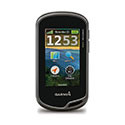


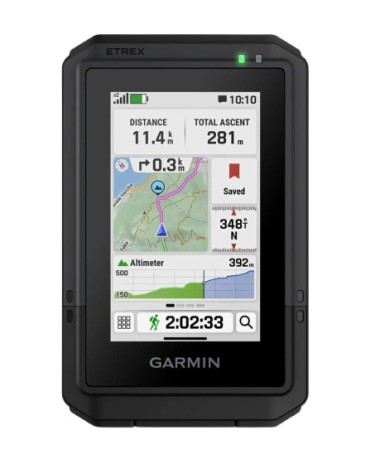
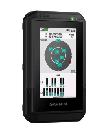
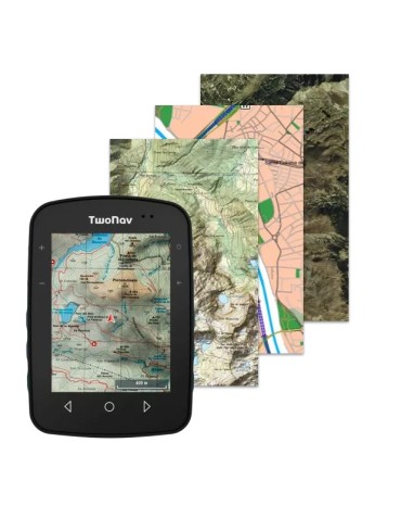
Garmin ofrece el Etrex 32, un GPS de mano con pantalla en color de 2,2" legible bajo la luz del so, también incluyen mapas TopoActive de Europa preinstalados con carreteras y senderos con función de establecimiento de rutas para cuando vayas en bici o hagas senderism y compatibilidad con los sistemas por satélite GPS y GLONASS para ofrecer un mejor seguimiento en entornos más remotos.
CARACTERÍSTICAS
| DIMENSIONES DE LA UNIDAD (ANCHO/ALTO/PROFUNDIDAD) | 5,4 x 10,3 x 3,3 cm |
|---|---|
| TAMAÑO DE LA PANTALLA (ANCHO/ALTO) | 3,5 x 4,4 cm; 5,6 cm en diagonal (2,2") |
| RESOLUCIÓN DE PANTALLA (ANCHO/ALTO) | 240 x 320 píxeles |
| TIPO DE PANTALLA | TFT transflectiva de 2,2 pulgadas de 65 000 colores |
| PESO | 141,7 g (con pilas) |
| BATERÍA | 2 pilas AA (no incluidas); se recomienda NiMH o litio |
| AUTONOMÍA DE LA PILA/BATERÍA | 25 horas |
| CLASIFICACIÓN DE RESISTENCIA AL AGUA | IPX7 |
| RECEPTOR DE ALTA SENSIBILIDAD | |
| INTERFAZ | mini USB |
| MEMORIA/HISTORIAL | 8 GB |
Mapas y memoria |
|
| MAPAS PREINSTALADOS | Sí (TopoActive de Europa; con función de establecimiento de rutas) |
|---|---|
| POSIBILIDAD DE AGREGAR MAPAS | |
| MAPA BASE | |
| CREACIÓN AUTOMÁTICA DE RUTAS (GIRO A GIRO EN CARRETERA) | |
| SEGMENTOS DEL MAPA | 3000 |
| BIRDSEYE | 250 BirdsEye Imagery files |
| INCLUYE ACCIDENTES HIDROGRÁFICOS CON UN ELEVADO NIVEL DE DETALLE (LÍNEAS DE COSTA, LÍNEAS DE COSTA DE LAGOS Y RÍOS, PANTANOS Y ARROYOS PERENNES Y ESTACIONALES) | |
| INCLUYE BÚSQUEDAS DE PUNTOS DE INTERÉS (PARQUES, ZONAS DE ACAMPADA, ATALAYAS PINTORESCAS Y ZONAS DE PICNIC) | |
| MUESTRA PARQUES NACIONALES, REGIONALES Y LOCALES, BOSQUES Y PARAJES NATURALES | |
| ALMACENAMIENTO Y CAPACIDAD DE CARGA | Tarjeta microSD™ (no incluida) |
| WAYPOINTS | 2000 |
| TRACKS | 200 |
| TRACKS | 10 000 puntos, 200 tracks guardados |
| RUTAS | 200 |
Sensores |
|
| GPS | |
|---|---|
| GLONASS | |
| ALTÍMETRO BAROMÉTRICO | |
| BRÚJULA | Sí (tres ejes con inclinación compensada) |
| BRÚJULA GPS (EN MOVIMIENTO) | |
Funciones inteligentes diarias |
|
| MANDO A DISTANCIA PARA VIRB® | |
|---|---|
Funciones de ocio al aire libre |
|
| NAVEGACIÓN PUNTO A PUNTO | |
|---|---|
| COMPATIBLE CON BASECAMP™ | |
| CÁLCULO DE ÁREAS | |
| CALENDARIO DE CAZA Y PESCA | |
| INFORMACIÓN ASTRONÓMICA | |
| MODO GEOCACHING | Sí (paperless) |
| COMPATIBLE CON LOS MAPAS PERSONALIZADOS | Sí (100 mosaicos de mapa personalizados) |
| VISOR DE IMÁGENES | |
Conexiones |
|
| CONECTIVIDAD INALÁMBRICA |
yes (ANT+®) |
|---|---|
Adicional |
|
| CARACTERÍSTICAS ADICIONALES | Conectividad inalámbrica: ANT+ |
|---|---|

Ficha técnica
Referencias específicas
Garmin ofrece el Etrex 32, un GPS de mano con pantalla en color de 2,2" legible bajo la luz del so, también incluyen mapas TopoActive de Europa preinstalados con carreteras y senderos con función de establecimiento de rutas para cuando vayas en bici o hagas senderism y compatibilidad con los sistemas por satélite GPS y GLONASS para ofrecer un mejor seguimiento en entornos más remotos.